City of Alameda Transportation Projects
Central Avenue: The concept for this project includes a reduction from four to three travel lanes, a center turn lane, bike lanes in the Gold Coast area, a two-way separated bikeway in the west end to Washington Park, street trees/rain gardens and intersection improvements such as roundabouts, curb extensions, pedestrian refuge islands, rectangular rapid flashing beacons and new crosswalks.
Cross Alameda Trail Overall: This project, which is being built in segments, is envisioned as a premiere cross-town, low-stress four-mile bicycling and walking corridor that will connect the west side of the island to the east, from the Seaplane Lagoon at Alameda Point to the Miller-Sweeney (Fruitvale) Bridge.
Clement Avenue: This project consists of a two-way bikeway on the north/estuary side of the street, curb extensions, sidewalk/curb ramp improvements and railroad track removal. It forms a 1.2 mile segment of the Cross Alameda Trail.
Clement Avenue/Tilden Way: This project will use the abandoned railroad right-of-way along Tilden Way and the eastern terminus of Clement Avenue. It will also build the most eastern segment of the 4-mile east-west Cross Alameda Trail, and will directly connect to the Clement Avenue Safety Improvement project, which also is part of the Cross Alameda Trail.
Estuary Bridge: Alameda, in partnership with the City of Oakland and others, is working to create a vastly improved estuary crossing for people traveling on foot, wheels and bicycle. A new moveable bicycle/pedestrian bridge is envisioned that would create an easy-to-use, safe and enjoyable connection, filling the significant gap in walking and biking facilities between the West End of Alameda and Oakland.
Fernside Boulevard Traffic Calming and Bikeways Project: This project aims to create a design concept to update Fernside Boulevard from Tilden Way to San Jose Ave. It will also develop an interim concept for Fernside from Tilden Way to High St that can be implemented with pavement resurfacing in the near term.
Grand Street Resurfacing and Improvement Project: The City has identified Grand Street between Shore Line Drive and Encinal Avenue as a high priority for pavement improvements. The project also is considering safety improvements such as high visibility crosswalks, curb extensions, flashing beacons at Wood School and at the Grand Street/San Antonio Avenue intersection, a protected bike lane for Wood School access/egress, enhancements to bike lanes including buffering where space is available, enhanced bus stops by Shore Line Drive and Wood School, and narrower travel lanes to encourage slower vehicle speeds.
Lincoln/Marshall/Pacific Avenue Improvement Project: Street design improvements on this corridor from Broadway to Main Street, 3.1 miles with community outreach and draft concept completed in 2022, and Council endorsement of the concept in 2023.
Mecartney Road/Island Drive Improvements: As a key intersection on Bay Farm Island, the Mecartney/Island Improvement Project is in the City’s Capital Improvement Program totaling $300,000 from Measures B/BB monies to fund an analysis and outreach effort so as to improve this busy intersection bringing it up to current best practice standards for safety, adjacent bus stops, path crossings and aesthetics.
Willie Stargell Avenue: The City is seeking grant funding to make improvements to Stargell Avenue between Main and Fifth Streets, including separate walking and bicycling paths in the vacant right-of-way north of the roadway, intersection safety and access improvements at the crossings and transit queue jump lanes at either end of the project.
The above projects are funded by a variety of federal, state and local sources including the gasoline tax - SB 1 monies - and the countywide transportation sales tax - Measure BB, which is administered by the Alameda County Transportation Commission.
Other Transportation Projects (Not led by City)
Doolittle Drive: Doolittle Drive in Oakland is expected to be an entry point for coastal flooding at the 100-year flood event. City staff are working with the key stakeholders - Caltrans, the Port of Oakland, East Bay Regional Park District and the City of Oakland - to seek funding for the project so as to bolster the seawall barrier to keep out bay water.
Encinal Avenue: This Caltrans project restriped and improved State Route 61 (Encinal Avenue) between Sherman Street/Central Avenue and Broadway by resurfacing the street, implementing a road diet from four lanes to two lanes, and adding a center turn lane and bike lanes. Construction is being completed in 2023. The Caltrans staff contact is Janis Mara at Janis.Mara <at> dot.ca.gov
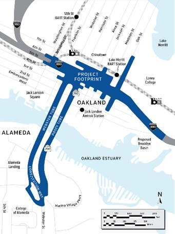
Oakland Alameda Access Project: This $152 million project, led by the Alameda County Transportation Commission (Alameda CTC), includes improvements to the Jackson Street on-ramp and off-ramp, Sixth Street, Webster Tube entrance from 5th & Broadway, adjacent streets in Alameda and Oakland, and a new (4 foot) pathway for people walking and biking in the Webster Tube plus the elimination of the Broadway off-ramp. The City of Alameda actively engaged with Alameda CTC and the City of Oakland on the project scoping, planning, environmental and design phases. Construction plans will be finalized in 2024, and the project is expected to begin construction in Spring 2025 and be completed by Fall 2027. This September 2023 Alameda CTC presentation provides a helpful overview of the project design, schedule, and construction phasing:
Presentation(PDF, 4MB)
The City of Alameda’s Transportation Commission considered this project at their October 28, 2020 meeting, and the City Council at its November 17, 2020 meeting. The City submitted comments on the draft Environmental Document(PDF, 186KB) in December 2020.