Alameda Wellness Center/McKay Avenue Project: FAQ
1. How much would the City have to spend to create a new park if Measure B were to pass?
If Measure B is passed, the City would have to incur significant costs to convert the property for use as a public park. First, the City would have to purchase the land, which is estimated to cost $5.5 million.
Second, to make space for a new park, the City would have to demolish the old Navy buildings on McKay, which include hazardous materials, and third, the City would have to build a basic 3-acre park with grass, a playground, and picnic areas, which together with demolition and removal of hazardous materials would cost approximately $6 million.
In total, the City would have to spend over $11.5 million to purchase the land, demolish the buildings, and build a very basic 3-acre park with grass, a playground, and picnic areas.
2. Will Measure B help expand Alameda’s parks?
No, Measure B only changes the zoning of the land on McKay to open space. Measure B does not create a public park; it does not change the ownership of the site, and it does not provide funding to purchase the property and improve the property for a park.
3. How much parkland does Alameda have now?
Alameda has 579.5 acres of public parkland, including the City’s 24 parks, and Crab Cove and Crown Beach, which are owned by the East Bay Regional Park District. In 2018 alone, the City opened 33 acres of new parkland with Estuary Park and Sweeney Park. The City anticipates opening an additional 14.5 acres of parks by 2022, including Alameda Landing Waterfront Park, parks in Site A at Alameda Point, and initial public access in Northwest Territories at Alameda Point.
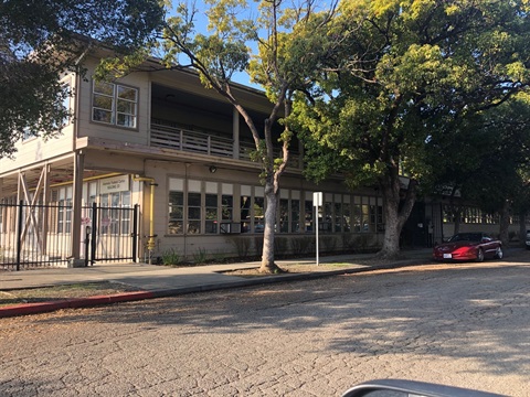
4. Has an application been submitted for development of the approximately 3.65 acre site along McKay Avenue that is being surplused by the federal government (“Project Site”)?
Yes. On April 19, 2018, Alameda Point Collaborative submitted a Planning Permit Application to remove the Special Government Combining District (G) overlay and revise the General Plan designation for the Project Site from Federal Facilities to Office to be consistent with the underlying zoning for the Project Site.
5. Is APC proposing a homeless shelter, an emergency shelter, or a “warming shelter” on the Project Site?
No, APC is not proposing any type of shelter or temporary residence for homeless individuals and/or families on the Project Site.
6. What is APC proposing on the Project Site?
APC proposes to develop the Project Site as a recuperative care and senior housing facility with medical services as well as a resource center for Alamedans who are at risk for homelessness or newly homeless. The proposed uses include:
-
A facility to provide housing and general care for highly vulnerable homeless elders with complex medical conditions;
-
A facility for the recuperative care of homeless convalescing patients with medically complex conditions departing from hospitals or undergoing intensive medical treatment;
-
Primary Care Health Clinic providing on-site medical and mental health care for residents and clients of the recuperative care and senior housing facilities; and
-
Resource Center with offices for case workers and outreach workers to meet with clients.
7. Can the Wellness Center be turned into a homeless shelter in the future?
No. Homeless shelters are defined as "emergency shelters" in our zoning code and are not permitted in the AP zoning district in which the Wellness Center is located. The AP zoning district does allow assisted living, medical offices, hospitals, and office use, but not homeless shelters. As the private property owner, Alameda Point Collaborative will be subject to all the rules, regulations, and standards of the zoning for the site. Any and all improvements to the property will be subject to review for conformance with City zoning requirements and the California Building Code.
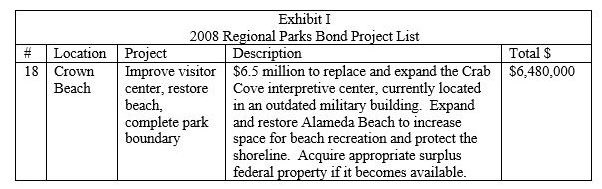
8. Didn’t Measure WW Require EBRPD to Acquire the Project Site?
No. Bond Measure WW was a 2008 ballot measure that authorized the East Bay Regional Park District to issue and sell up to $500,000,000 in bonds to complete the East Bay Regional Park District Master Plan for parklands and open space. Measure WW identified funds for the acquisition and development of surplus federal property adjacent to Crab Cove to expand and improve Crown Beach. An excerpt from the Sample Ballot can be found below:
9. Wasn’t the Project Site rezoned to Open Space in 2014?
No. In 2014, the proponents of the “Initiative for Expansion of Open Space at Crab Cove” circulated and qualified an initiative to rezone a 3.899-acre parcel of surplus federal property (“EBRPD Site”) to Open Space. The property was bounded by multi-family residential uses to the west, federal office and research buildings utilized by the U.S. Department of Agriculture to the north, an EBRPD visitor center and parking lot to the east, and an EBRPD maintenance facility (corporation yard) and building called “Glory of the Seas” to the south. The EBRPD Site was improved with two federal office buildings and a parking lot, and subsequently conveyed to the East Bay Regional Park District.
On July 1, 2014, the City Council adopted Ordinance No. 3102(PDF, 24MB) approving the rezoning rather than placing the initiative on the ballot. The only property that the ordinance rezoned to Open Space was the EBRPD Site. No other land in the City was affected.
10. What is the Settlement Agreement that everyone is referring to?
On October 21, 2015, the federal government, the State of California, and the East Bay Regional Park District entered into an agreement to resolve disputes arising out of the federal government’s filing of a Declaration of Taking for the parcel known as McKay Avenue and an adjoining sidewalk easement (“Settlement Agreement(PDF, 4MB)”). The City of Alameda is not a party to the Settlement Agreement.
11. Does the Settlement Agreement address the EBRPD Site and the Project Site?
Yes. The Settlement Agreement(PDF, 4MB) addresses both sites, but refers to the EBRPD Site as “Neptune Pointe” and the Project Site as the “Retained Parcel.” The Settlement Agreement describes the transfer of Neptune Pointe from the federal government to EBRPD and specifies that the federal government will continue to own and operate the Retained Parcel.
Section 5 of the Settlement Agreement states the following:
-
The Retained Parcel may be subdivided and fully developed in the future;
-
EBRPD and State Parks will not interfere, legally or otherwise, with the use or transfer of any portion of the Retained Parcel, including any use consistent with the neighboring area by a private purchaser;
-
EBRPD and State Parks shall not participate in or seek to influence any change of zoning for the Retained Parcel as long as the parcel is owned by the United States or a direct purchaser from the United States; and
-
EBRPD and State Parks will not oppose a project of a Direct Purchaser of the Retained Parcel on a wholesale basis.
12. Is the Project Site zoned as Open Space?
No. The Project Site is not zoned as Open Space.
13. What is the zoning designation for the Project Site?
The Project Site is zoned Administrative Professional (A-P), which is applied to areas where administrative and professional offices, and medical and related facilities are the proper uses.
Because the Project Site is currently owned by the federal government, its General Plan land use classification is Federal Facilities and its zoning designation includes a Special Government Combining District (G) Overlay, which indicates that the land is owned by the federal government.
14. What uses are permitted in the Administrative Professional (A-P) zone?
The following uses are permitted at sites that are designated Administrative Professional (A-P): administrative and professional offices, medical facilities (including, but not limited to dental clinics, hospitals, medical clinics, medical laboratories, nursing and convalescent homes, radiologist labs, rest homes, and sanitariums), and incidental or accessory buildings. (Alameda Municipal Code, § 30-4.7).
15. What is the City Council’s role in the process?
When any federally owned property in Alameda is transferred to private ownership, the City Council must hold a public hearing to change the General Plan designation (Federal Facilities) to be consistent with the underlying zoning and remove the Government Combining District (G) zoning designation. On December 4, 2018, the City Council of Alameda requested that City staff prepare an analysis of the proposed Initiative specifically addressing the Initiative's potential impacts on other land uses in Alameda, potential fiscal and economic impacts, and possible legal issues associated with the Initiatives language and implementation. This report was presented to the City Council at its regularly scheduled meeting on January 2, 2019, and can be downloaded here(PDF, 12MB).
16. There are allegations of misrepresentation by signature gatherers and intimidation tactics in attempts to gather or prevent signatures. What can I do about that?
The initiative process and elections are fundamental elements of democracy and protected as free speech. If you believe signature gatherers are misrepresenting the issue, a complaint can be filed with the Alameda County District Attorney’s Office. If someone is attempting to intimidate you into signing or not signing an initiative petition or obstructing your ability to participate in the democratic process, you should call the Alameda Police Department, as such activity could constitute a crime.
Additional Information:
- 2014 Staff Report(PDF, 20KB) and attachments regarding initiative: revisions to the ordinance(PDF, 14KB), elections code report(PDF, 17MB)
- September 2018 Environmental Analysis(PDF, 9MB)
- Letters from the Department of Health & Human Services regarding the Environmental Assessment: December 13, 2017(PDF, 668KB), June 13, 2018(PDF, 73KB)